|
|
This trip really started in 2007. I had a good climb up Shasta's West Face and wanted to do more that summer. I sent Bob Ayers some email saying "OK, I've climbed all the non-Sierra California 14ers, time to do one in the Sierra."
See all the pictures.
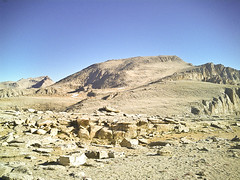
Mount Langley is one of the easiest California Fourteeners to climb if the Army Pass route is chosen. Langley provides a great view of the south Sierra in all directions from the summit, including the Mount Whitney group, the Great Western Divide, Olancha Peak, and Owen's Valley. It is the southernmost fourteener, and the most desert-like of the Sierra Nevada fourteeners. Some people do it in a day from the 10,000' trailhead, but that wasn't our idea of fun. Bob has climbed a lot of peaks in the Sierra and most of the 14ers, but not Langley - so I knew I could sucker him in.
We had planned to go up Langley in 2003, after climbing White Mountain. That didn't work out for a number of reasons. We figured we could take the long Labor Day weekend to drive down and knock it off ... we should know better by now.
|
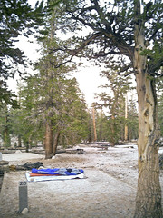
We got to the ranger station in late afternoon, had a nice dinner at Margie's Merry Go-Round, and wandered our way up to Horseshoe Meadow. The trailhead camping was largely deserted, which suited us fine. The only stove we brought was my Jetboil, by prior agreement - Bob was willing to do no-cook, but I wanted morning coffee. I was willing to carry an extra pound for that.
The weather was great, no threat of rain, a little chilly at night. We spent a pleasant evening under the stars and a relaxed morning trying to get a little acclimatization. I had brought a small ham radio but didn't have any luck making contacts ... oh well. After lunch, we started walking into the Golden Trout wilderness, headed for (Old) Army Pass.
This Army Pass thing is fascinating to me. Apparently the Army built the old pass and abandoned it within 10 years because it faces the wrong direction and thus remains snow covered well into the summer. That would have been in the 1930s - the trail has not been officially maintained since then and is apparently in great shape, despite having disappeared from all known maps. New Army Pass is the replacement, considerably further south; the main disadvantage of New Army Pass for Langley is that you have to walk past Army Pass to get to Langley - which means losing about 250 feet of elevation. That's why we chose the Army Pass route.
|

|
We spent about 3 hours scree scrambling before deciding that we had
completely blown it - there was no trail here.
Worse, we had seen someone
walking along the north side of the lake on what seemed to be an
easy trail. But no, we were stubborn, the trail must be here.
Eventually, we figured it out. Around noon. So we went back to
our campsite, packed up, walked out to the car and started driving home.
We wandered through Whitney Portal, had dinner at Harris Ranch,
and got home in plenty of time.
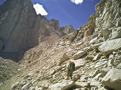
The basic strategy for the East Face is to leave the Whitney Portal trailhead (8340') early in the morning and climb all the way to Iceberg Lake (12000') by afternoon. This amount of climb with a heavy pack ... concerned me. So I was up dreadfully early two or three mornings a week to chug around a local loop - 3.5 miles, about 700' gain - with a heavy pack. I started at 30# and worked my way up to 50#, always under an hour ... my knees didn't like that much, but ibuprofen is my friend.
Bob & I decided on the same basic plan ... but gave serious consideration to going over New Army Pass, just to be safe. Even though we were now certain of where the trail to Army Pass is, it seemed better (less likely to lead to embarrassment!) to follow signs. And, at the last minute, that's what we did.
So, another night at Horseshoe Meadows. This time, the campground was crowded and we had a hard time finding a pad. The weather was questionable - it had rained up there before we arrived, and there were threatening clouds. Bivy sacks all around.
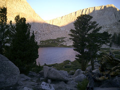
It was a chilly, clear night, but we didn't get wet. The crowds mostly cleared out after their breakfast - the majority were a work party from Friends of the Inyo that was headed in to do trail maintenance for several days. We hung out until lunch, packed up slowly, and started walking around noon. We followed the signs to New Army Pass - looking at the map, we decided that the right place to camp was Long Lake (11,120'), or possibly the lake higher above it. We had threatening clouds all day, but no rain. We found our way to Long Lake, dropped out gear, and walked up to the final lake (South Fork Lake at 11,400) but decided that there weren't good campsites there. Early dinner, slide into the bivvy sacks to get away from the mossies, fitful sleep.
|
We spent the next couple of days in and around Lone Pine - mostly trying to stay above 9000' during the day but still eating and sleeping in modern comfort. We visited the Onion Valley, Baxter Pass and Big Pine trailheads, and I got my first relatively close look at the Palisades. Next trip.
I was to meet the guide at the Whitney Portal trailhead at 7:30. Bob & I figured that I certainly should sleep the last night at elevation. A quick survey of the Whitney Portal camping led us to realize that sleeping there was a bad idea. We drove back up to Horseshoe Meadow, snagged what seemed to be the last available campsite (where did all these people come from on a Thursday night?) and prepared ourselves for an early morning.
We weren't the first up at the campsite, but it was chilly and dark by the time we had the car packed. We trundled off to Whitney Portal, believing the web site that indicated that the store would open at 7am - I wanted a hearty breakfast. It's a good thing I had a backup plan, because nothing stirred in the store until 7:30 and I wasn't able to get coffee until 8:00!
I hung around at the designated meeting spot, waiting for the others to show up. At this point, I was still looking for another client - no one likely was around, including no likely guide. Eventually, Chris Simmons showed up alone, and told me that the other client cancelled. It would be just the two of us.
|
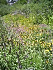
The hike up is a long slog, punctuated by a few items of note. The Ebersbacher ledges are notorious to some - they're wide enough (about 18") and straightforward to walk across, but have glorious exposure that stops some people in their tracks. We stopped for lunch below Upper Boy Scout lake, after following an indistinct trail through waist-high wildflowers in bloom.
|
We spent a pleasant afternoon and evening breathing thin air, cooking dinner, getting settled in among the rocky windbreak, swapping stories, arguing about gear (and daisy chains), and speculating about the other climbers in the immediate area. It's quite a cirque up there, with quite a lot of interesting rock to climb. We crawled into our bags early, planning a crack-of-dawn start, I in my bivvy sack and many of my clothes, Chris in his Feathered Friends "elephant's foot" (at 70", it was really the whole foreleg) and pretty much everything in his pack.
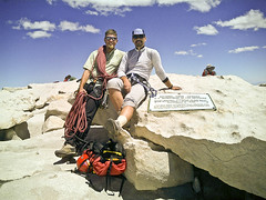
The climb is well-described in many places on the web: the Loma Prieta Climber's Guide is certainly a good place to start. I found the climb to be just perfect: hard enough, especially combined with the altitude, to be a good challenge, but never so hard as to seem impossible. I admit that the last corner/offwidth stopped me for a few seconds - we hauled my (too big) pack and that made it a whole lot easier mentally. Everyone builds up the Fresh Air Traverse as the most difficult portion, but I didn't find it so bad - the exposure is thrilling,, but it felt very secure (if you're comfortable with friction, I guess). I found the first pitch, both the long-step traverse and the corner/chimney at the end, to be much more daunting. There was no one else on the route except for one soloist - he passed us just before the Fresh Air traverse. He had already done the East Buttress, and was planning to do (I think) the Keeler needle next!
|
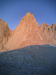
We crashed, ate, sunned, filled water bottles, cooked supper, had a visit from another climbing team, swapped stories, fell asleep. I woke up early for some reason (oh yeah, our neighbors had an alarm set for 4:30), so I tried to capture Whitney as the sun hit it. I got at least one reasonable image, but my friend Karl Bralich (aka Karlee Baba) did a much nicer job of capturing the area around Iceberg Lake.
That's about it - the next morning was the hike out, uneventful and reasonably quick. We traded some of our gear with another group on the way down, thus lightening our loads. The Ebersbacher ledges passed pretty much without comment. Burger and beer at the store tasted grand; putting on clean(er) clothes and different shoes made a huge difference. Bob & I were on the road by 13:00, had dinner at Harris Ranch, took a detour through Mendota and Firebaugh to avoid a backup on I-5 and were home ... pretty late. But in plenty of time to be at work the next morning!
back to the mountaineering page